
Perfect Universal GPS for Geocaching and Navigation
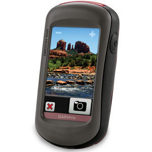
My rating and comments are based on being a Geocacher and using this unit specifically with Geocaching as well as on-road navigation. Any views given will be from a Geocacher's perspective. I own and have used many GPSr units and of all the units would HIGHLY recommend this unit over many others. It's a GREAT all purpose and fairly easy to use device. Additionally, because it's a 550T it has the added features of both the TOPO maps and a camera, so it's less equipment to carry if you enjoy taking pictures while you are out. The 500 series has neither the TOPO maps or camera built-in (you can purchase TOPO and other maps separately for all devices). A quick breakdown of which unit has which features: 500 - basic GPS unit 500T - GPS unit plus the additional TOPO maps 550 - GPS unit and Camera 550T - GPS unit, camera and has the TOPO maps. *at times I will refer to it as the 5XX series because other than the differences in features all the 500 series perform the same. Prior to purchasing this unit I also owned the Oregon 400T. The 400 is okay, but lacks the speed and accuracy of this unit. I have also used various other GPS units either via owning them or via using my friends devices, so comparatively I can say this device is a good mid-range unit that will give you ease of use and a nice well-rounded assortment of features. 1. Holds a reasonable amount of Geocaches for a weekend of caching in a specific area. If you would like to hold more caches I would recommend using it in conjunction with GSAK, but that is a whole other area and outside the scope of this review. 2. Has the CHIRP feature (some earlier units do not support this). The CHIRP is a GARMIN device that can be used with caching to create a different caching experience. GARMIN GPS units at the time of this review are the only units to support this feature. A CHIRP is a "one-of-a-kind wireless beacon designed specifically for the outdoor adventures of Geocaching" it is "compatible with most outdoor handhelds that have the ability to wirelessly transfer or receive waypoints, routes, tracks, and geocaches". I have done many CHIRP caches and it depends on the creativity of the CO (Cache Owner), but they can be a fun addition to Geocaching. 3. Has Wherigo game as part of the OS. This is the LAST GARMIN device to have the WIG built-in (the newest release the MONTERRA has an APP feature that can be downloaded, but GARMIN no longer supports the WIG inherently. The App to support this on the Monterra is through the Android market.) One of my favourite features on this device is that is does the WIG. Wherigo is a GPS location-aware software platform created by Groundspeak (also known as Geocaching.com) -- it is not a GARMIN product, though initially GARMIN supported it. A Wherigo is a mix between an adventure game and a geocache search. You will download a "cartridge" to play the game. Depending on how the CO created it can be used to create puzzle to be played ahead of time (called play anywhere) and then you go find the cache when you solve the puzzle and are given the coordinates, or you can be a part of the action by being a character and pick-up virtual objects, something kids of all ages will enjoy. The abilities of the WIG feature are limited only by imagination of the CO. It's one of the features I really enjoy on the Oregon 5XX series. I was sorry to see them remove this feature from their GPS units. If you have access to either an iPhone or Android, you can DL the software needed to run this application too. If you don't have access to the WIG through those devices, then this unit will really be ideal addition to your Geocaching tools if you find that you would enjoy this feature. 4. Switching between profiles is easy and very useful. I have a profile set-up for my CHIRP, one set up for AUTOMOTIVE navigation and one set up for GEOCACHING. Rather than leave the CHIRP on all the time (which uses battery power) I have it off in my main profile (GEOCACHING), but have it ON in my CHIRP profile. At the push of a single button I am in the CHIRP profile and just a single push I'm back to the main profile after completing the CHIRP. When I am navigating to a cache that is farther away and needs to be routed via the road, rather than through the woods, it's a simple as a push of the PROFILE button and I can navigate to that cache via Automotive routing, and as I near my destination, I can then switch back to direct navigation by choosing my main profile. This is a great feature and if used correctly can really make the ease of caching verse road navigation a breeze! 5. Maps, maps, maps...there are maps for almost everything you need, road maps, trail maps, TOPO maps (installed on the T versions of the GARMIN units)...but you can also make your OWN maps. This takes additional skill and a quick search on YouTube, but you can use Google Earth and a KMZ file to create your own trail maps, that you can use on the unit in conjunction with the caches and you will be able to see how far off a trail a cache is or which trail you should take verse another. 6. Has nice 3.2 megapixel digital Camera. Great because it's built to hold up to more rough-and-tough handling as well as wet than most of your everyday cameras. It definitely holds up better than dropping your phone camera in the water or onto a rocky terrain. As a point-and-shoot camera it is comparable to others with the same megapixels and easy to use AND you don't have to carry anything extra with you. It does have the disadvantage of no strap if you prefer the security of knowing it won't slip you'll need to purchase that separate (but I think it's only a neck version, can't say for sure as I've not used that feature, I just lock my fingers through the carabiner). 7. Navigation with this unit is good, accuracy is dependent on many factors as is with all GPSr units. You have to take into consideration the weather, the overhead obstructions, nearby large 'magnetic' type objects (rocks can affect this too), and time of day plus other factors, but overall it is generally decent. There are some days where it is very accurate and some days where you're within 20 feet. Still it's much more accurate than the 4XX series. It uses the standard GPS, if you want the GLONAS or other satellite systems you'll need a more recent model, but then you trade off some features as well as a much bigger cost). 8. This unit will get you where you need to go at a nice price range and if you are an average cacher (not a power cacher where you need numbers) then this GPS should also hold enough caches for you (again if you want a bit more consider looking into GSAK). 9. Has the ability to switch to various UNITS of measurement depending on how you wish to use the device. I put mine on MILES >YARDS >FEET (meaning you have to select Yards in the units choice) for the most accurate measurements. If you are more than a mile away it will show in miles, once you are below a mile it switches to yards, and it switches to feet below a 1/2 mile. I find that when you are in the woods with the canopy as an added factor blocking the satellites this is the most accurate way to determine if you are headed the correct direction. Given that if you stand still for any amount of time, such as when you are taking a water break or trying to get your bearings the compass does tend to bounce off course for a bit until you begin moving again, you can travel for a bit before knowing you are headed the wrong direction without the most accurate directions being reflected on your GPS device. The other choices are miles and feet, this will show miles in 10th unit increments until you are within 300 or so feet, problem I have with this version is that when you are 3-10ths of a mile and are walking the wrong direction, you won't know it for some time as the units do not decrease at a quick rate compared to using yards where every 3 feet you know if you are going lower in numbers or higher in numbers. But then that's just my perspective on it...you will find what works best for you when you are out in the field. 10. While there are probably many more features that should cover the main ones, I'll end here with a couple last notes: make sure you have the most recent updates as there were a couple glitches that were resolved with the updates. Be sure to calibrate before starting. Wait until the GPS is showing that it has signals before attempting to use it as you won't get an accurate read. If marking waypoints, use both averaging and single marking to get the most accurate reading. Overall this is a great mid-range unit and a good price. I have recommended it to friends and will continue to do so even though I also have other more recent units. No compensation has been made to me for this recommendation and if View Points had the most recent GARMIN GPS unit you would see a scathing review by comparison. :( Processing Speed For the most part the processing speed is good, though the more caches you have loaded does seem to slow the start-up down, and there are a couple times when switching between caching to camera is slower, but for everything this unit does, the speed is good. Map Quality & Accuracy Maps are accurate as long as you keep the updated they are great. Ease of Use This GPSr is user friendly, however, it does have a learning curve. The owner's manual is on-line, although a quick start is provided you don't get nearly the use of this unit with only the quick-start guide. The touch-screen is quick and easy to use, you can change/organize the main page to how you use the unit, you can set up different 'profiles' to make changing between how you use for one type of activity to the next with a click of a button. Of ALL the units I have purchased, this was the quickest for me to learn, but that may have been impacted from being a prior GARMIN owner.
StampMyArt
Coventryville, PA